 Gwadar Investment Opportunities
If you’re looking for a panoramic beach view, world-class amenities, and a superb property investment opportunity, Sangar Housing Scheme offers a stunning location off the coast of Baluchistan province in Pakistan. The housing scheme comprises 4400 acres of pristine land, offering plots for sale, farmhouses, commercial areas, and recreational facilities. However, with such a large property area, navigating the Sangar Housing Scheme can be daunting. Luckily, this blog post will serve as your comprehensive guide to understanding the Sangar Housing Scheme Map.
Overview of Sangar Housing Scheme
Before we delve into the map, let’s take a quick tour of Sangar Housing Scheme’s layout. The scheme is situated between the Arabian Sea and the Coastal Highway, featuring three sections commercial, residential, and recreational. The scheme is divided into 10 sectors, each offering different plot sizes, and developed with surrounding infrastructure such as roads, water, and electricity.
Why Location Matters in Real Estate?
Location plays a vital role in determining the value of a property. It affects various things such as accessibility, views, amenities, and surroundings. By choosing the right location, you can ensure that your investment holds value in the long run. Bearing this in mind, it is essential to know the Sangar Housing Scheme Map before investing in any plots.
Understanding Sangar Housing Scheme Map
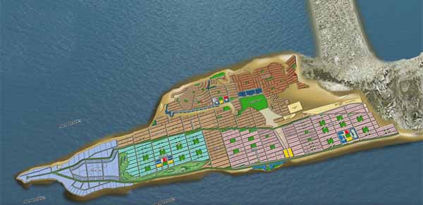
The Sangar Housing Scheme Map is the key to understanding the layout and features of the scheme. The map is divided into three sections, namely commercial, residential, and recreational. Each section of the map is further divided into sectors, ranging from A to K. These sectors are further divided into blocks such as A1, A2, and so forth.
Commercial Area
In sector C of the Sangar Housing Scheme, you’ll find the commercial area. The commercial area features three blocks, each with designated commercial plots. Block C1 is the central hub with shops, offices, and supermarkets. Block C2 offers residential and commercial mix-use plots. Block C3 is for educational and healthcare facilities such as schools, clinics, and hospitals.
Residential Area
The residential area of Sangar Housing Scheme spans various sectors, including A, B, D, E, F, and G. Each sector and block has designated sizes and types of residential plots. The size of residential plots ranges from 125 square yards to 2000 square yards, with prices varying according to the sector and block.
Recreational Facilities
Lastly, Sangar Housing Scheme’s recreational facilities are situated in sector H. The facilities include parks, lakes, golf courses, and beach amenities. The recreational area is perfect for individuals looking to unwind and relax in a serene environment, away from the hustle and bustle of city life.

Key Features of the Sangar Housing Scheme Map
There are several unique features to each area within the Sangar Housing Scheme Map. For example, the Maroon sector is ideal for commercial purposes, while the Red sector is more suited to residential purposes. The Purple sector is designated to the Bahria town groups for constructing their projects. When selecting a plot, it is essential to factor in the area’s proximity to significant landmarks or amenities, such as the beach. Some areas have beautiful scenic views of the beach, while others are nearer to the entrance gate.
How to Choose Your Ideal Property on the Map
Choosing the perfect plot on the Sangar Housing Scheme Map can be challenging, especially if you are not familiar with the area or terminology. However, with a few considerations in mind, the process can be simplified. Firstly, it’s important to determine the purpose of your investment, i.e semi-commercial or residential. This will then help you select the ideal block within a particular sector. Another factor to consider is the distance from amenities such as parks, schools, and hospitals. This ultimately depends on your personal preferences and lifestyle.
Future Developments & Their Impact on the Map
The Sangar Housing Scheme holds a lot of promise in terms of future development and improvement. With the ongoing construction work in the city, Gwadar promises even more aspects of growth in the near future. Plans for the construction of a mosque, a hospital, and a school in the scheme are currently being formulated. The development of these projects is sure to increase property value in the area and have a significant impact on the layout of the Sangar Housing Scheme Map.
Conclusion
In conclusion, investing in a property can be a daunting task, especially if you are not familiar with the location or area. However, by understanding the Sangar Housing Scheme Map and its layout, you can make a more informed decision regarding your investment. Remember, it’s important to factor in your preferences, long-term goals, and lifestyle when choosing a plot. After all, you’ll want to ensure that your investment holds its value in the long run. This guide aims to make your decision-making process easier and help you navigate the Sangar Housing Scheme Map with ease. So, what are you waiting for? Invest in Sangar Housing Scheme and secure your future now!
